 The Latest Go-To Newsletter:
Are you ready for an adventure? Come and explore the beautiful outdoors near Winston-Salem! We have compiled a list of 6 nearby hiking trails and state parks that are less than 2 hours from the city. Enjoy our hiking near Winston-Salem guide!
Updated October 2023
Stone Mountain Loop Trail
TRIP | ~ 1 hour drive
DISTANCE | 4.5-mile loop
This trail, located in Stone Mountain State Park, takes you across the 600ft summit of Stone Mountain, by the Hutchinson Homestead (a restored mid-19th century mountain farm), and by a 200ft waterfall.
If you choose to do the entire loop there are a number of stairs, which is why this trail is rated ‘strenuous.’ However, hikers may choose to go to the waterfall or to the summit and back without doing the entire loop.
Stone Mountain State Park has something to offer for everyone – 18 miles of hiking trails, 90 campsites, climbing, fishing, picnicking, horseback riding, etc.

Hanging Rock Trail
TRIP | ~ 45 minutes
DISTANCE | 2.6 miles roundtrip
This trail, located in Hanging Rock Park, is rated ‘moderate.’ The trail begins in the Visitor Center parking lot. The trail starts out paved and turns into a combination of gravel, dirt, and rock as it gradually gains in elevation. It takes the average person 1 hour to reach the top.
The peak sits at an elevation of 2,159 feet. Hikers can rest on the peak and enjoy spectacular views of Moore’s Knob across the valley, Indian Creek below, and the Blue Ridge Mountains to the north.
Hanging Rock State Park also offers 20+ miles of hiking trails, 73 campsites, picnic areas, and a lake for swimming and canoe rentals.

Pilot Mountain
TRIP | ~ 30 minutes
DISTANCE | Multiple routes
The best thing about Pilot Mountain State Park is that it is only 30 minutes from Winston! There are several popular trails within the park – many of which can be done separately or combined for a longer, more challenging hike.
For an easy hike that gives you a lot of bang for your buck, check out the Jomeokee Trail – it is a moderate 0.8-mile loop around the base of the Big Pinnacle and has access to beautiful views and impressive cliffs.
If you want something a little more challenging, check out the Ledge Spring Trail – it is a strenuous 1-mile (one way) trail that connects from the Grindstone Trail and ends on the Jomeokee Trail. The trail travels along the foot of the cliffs and ledges to the west of Little Pinnacle. Hiking out and back from the summit parking area is a 2-mile strenuous hike.

Bluff Mountain Trail
TRIP | ~ 1 hour, 30 minutes
DISTANCE | 7.5 miles roundtrip
Bluff Mountain Trail is a 7.5-mile trail that is popular among “flatlanders,” as it offers many scenic vistas and traverses relatively level terrain. It runs from Brinegar Cabin to Basin Cove Overlook. This trail is wonderful to do with your fur friends because it is rarely crowded and feels more like walking through rolling hills and open pastures than a “hike through the woods.”
The view of the Blue Ridge Mountains along the trail is incredible! The trail starts at Doughton Park off the Blue Ridge Parkway (approximately milepost 241.1). Don’t let the 7.5 miles scare you, you can just do a mile or two and turn around as you wish – no need to do the entire trail to get to any spectacular views.

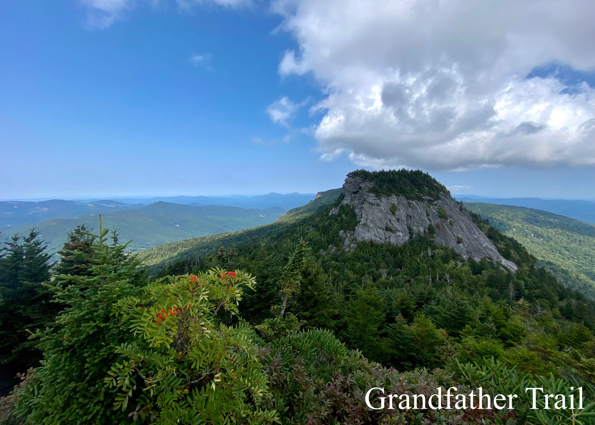
Grandfather Trail
TRIP | ~ 2 hours, 10 minutes
DISTANCE | 2.4 miles one-way
Grandfather Trail is a well-liked trail in Grandfather Mountain State Park! The trail runs the length of the summit ridge – starting from the mile-high swinging bridge and ultimately reaching Calloway Peak. It offers astonishing variety – running in and out of spruce and fir, across and around rock walls, and into open spaces with mountain views in every direction.
From start to finish this trail is not for the faint of heart. At times, you have to use cables to assist you in your climb over rocks, and steep ladders that will get your heart pumping. On your route to Calloway Peak, you will come across MacRae Peak, a 5,844 peak that you can climb onto and take in the incredible views of the Blue Ridge Mountains. This strenuous 4.8-mile roundtrip hike is certainly worth it.
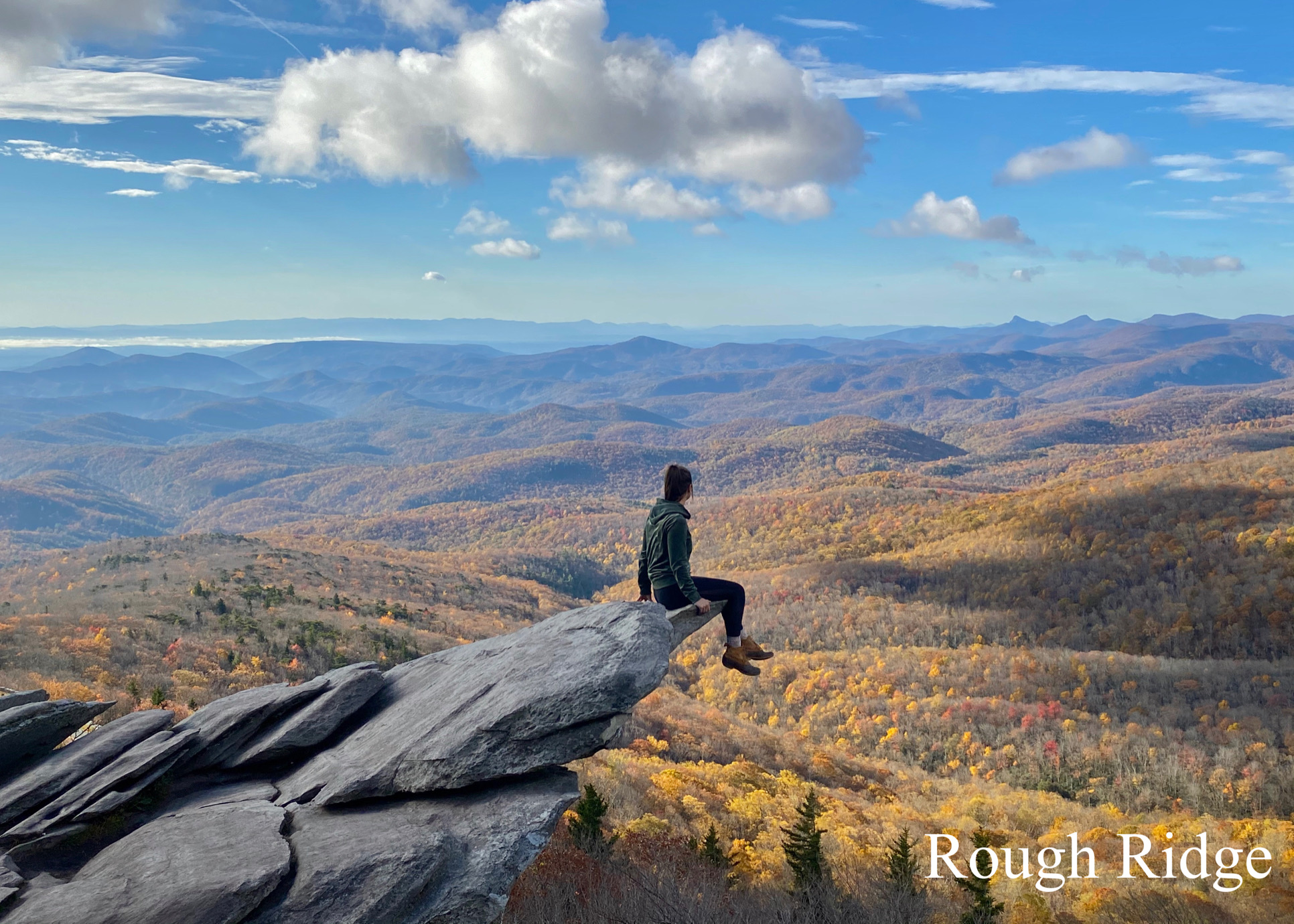
Beacon Heights / Rough Ridge
TRIP | ~ 2 hours, 15 minutes
DISTANCE | Multiple routes
The Beacon Heights Trail and the Rough Ridge Trail are only 2 miles driving distance from each other off the Blue Ridge Parkway, so you can knock them both out in one day.
The Beacon Heights Trail is at milepost 305.2 off the Parkway and offers a short, 0.6-mile hike through the forest ultimately arriving at two magnificent overlooks that offer wide, open views of the Blue Ridge Mountains. The trail only climbs only about 100 ft and is a great trail for children and dogs. This is the PERFECT trail if you are an early riser because the sunrises are simply unbelievable!
The Rough Ridge Trail at milepost 302.8 off the Parkway is one of the most satisfying hikes on the Blue Ridge Parkway, at 1.5 miles roundtrip. This popular spot is the perfect place to enjoy the fall foliage, a sunrise, and breathtaking views of the Blue Ridge Mountains. There are several large boulders along the trail that you can sit on to take in the views and get your Instagram-worthy pictures!
By Tori Landschoot
Tori has lived in Winston-Salem for 16 years. She lives with her husband and two adorable doodles. She enjoys hiking, all things outdoors, and DIY projects!